CLIMATE, WEATHER AND MONSOON
Introduction
- Weather refers to the state of atmosphere at a particular place at any given time denoting the short term variations of atmosphere in terms of temperature, pressure, wind, moisture, cloudiness, precipitation and other elements.
- Weather is highly variable from time to time, day to day and place to place.
- Weather is not constant. It is always changing within hours or a day.
- On the other hand, climate is the average weather conditions of an area for a long period of time.
- The World Meteorological Organisation(WMO) has suggested data for a period of 30 consecutive years to be referred for calculating the climatic averages of various weather elements. Climate is constant.
- It is a permanent condition of a place.
- The ancient Greeks called the tilt of latitude as ‘klima’, literally meaning ‘slope’or ‘inclination’.
- Then the earth was divided into seven latitudinal regions, called ‘klimata’.
- The word came into modern European languages as clime or ‘climate’, denoting the average weather condition.
Weather
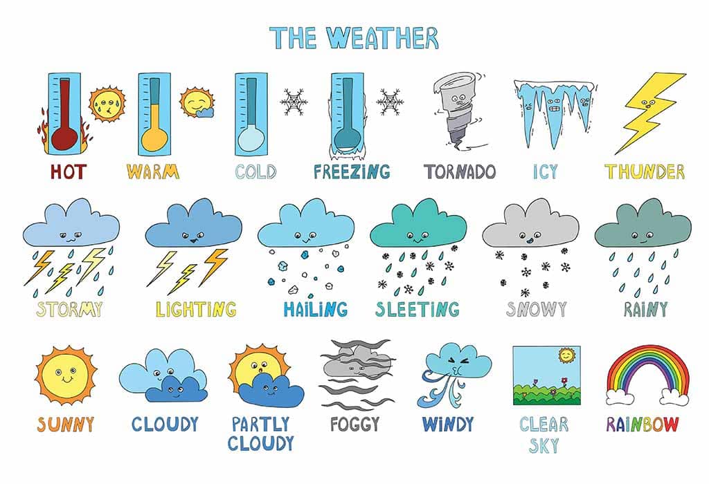
- Weather is the day today conditions(state) of the atmosphere at any place as regards sunshine, temperature, cloud cover, Wind fog condition, air pressure, humidity, precipitation and such other elements.
- It refers to short periods like a day, a week, a month or a little longer and as such the weather changes from time to time in a day and one period to the other in an year.
- In the morning the weather might be sunny with a clear sky in a place and evening there might be clouds and rain.
- Similarly the weather is cool in winter and hot in summer. We often hear people saying “Today the climate is good or bad”.
- It is incorrect to say like that. Instead it has to be said that the weather is good or bad.
- We could observe the television news readers saying weather report and not the climate report for e.g. cricket match have been postponed due to bad weather etc.
Climate
- Climate is generally defined as the average conditions (state) of the weather of a place or a region.
- The average atmospheric conditions are determined by measuring the weather elements for a long period of time which is usually for 35 years.
- The elements of weather and climate are the same. The climate does not change often like weather.
Controlling factors of weather and climate
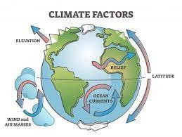
- Angle of the sun’s rays, the length of daytime, altitude, distribution of land and water bodies, location and direction of mountain ranges, air pressure, winds and ocean currents are the major factors which affect the weather and climate of a region.
- The earth is spherical in shape. So, the sun’s rays fall unevenly on the earth’s surface.
- The Polar regions receive slanting sun’s rays. Hence there is little or no sunlight, thus there is an extreme cold winters.
- Vertical sun’s ray’s fall directly on regions around the equator, hence the climate is very hot and almost no winters.
- The difference in temperature makes the air and water move in currents. Warm air rises and creates more space for air beneath, while cool air settles down.
Elements of weather and climate
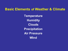
Temperature, rainfall, pressure, humidity and wind are the major elements of weather and climate.
Temperature
- Temperature is one of the key elements of weather and climate. The earth and its atmosphere get heated from the sun through
- The degree of heat present in the air is termed as temperature. Apart from sun’s rays, the heat in air also depends the atmospheric mass to a small extent.
- Temperature varies with time due to changes in the level of radiation which reach the earth surface.
- This is due to motions of the earth (The rotation and revolution) and inclination of the earth’s axis.
- The temperature influences the level of humidity, the process of evaporation, condensation and precipitation.
- Heat energy from solar radiation is received by the earth through three mechanisms. They are radiation, conduction and convection.
- The Earth’s atmosphere is heated more by terriestrial radiation than insolation.
Factors affecting the distribution of temperature
Latitude, altitude, nature of land, ocean currents, prevaling winds, slope, shelter and distance from the sea, natural vegetation and soil are the major factors which affect the distribution of temperature.
Measuring Temperature
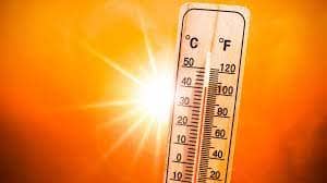
- The temperature of a unit volume of air at a given time is measured in scales like Celsius, Fahrenheit, and Kelvin.
- Meteorologist measures the temperature by the Thermometer, Stevenson screen and minimum and maximum Thermometer.
- The energy received by the earth through insolation is lost by outgoing radiation. Atmosphere is mainly heated by outgoing radiation from 2 to 4pm.
- So the maximum temperature is recorded between 2 and 4 pmregularly and minimum temperature is recorded around 4 am before sunrise.
Mean Temperature
- The average of maximum and minimum temperatures within 24 hoursis called mean daily temperature [(87oF+73oF)/2=80oF].
- Diurnal range of temperature is the difference between the maximum and minimum temperatures of a day.
- Annual range of temperature is the difference between the highest and lowest mean monthly temperatures of a year.
- The distribution of temperature is shown by means of Isotherms. Isotherms are imaginary lines which connect the same temperatures of different places.
Heat zones of the earth
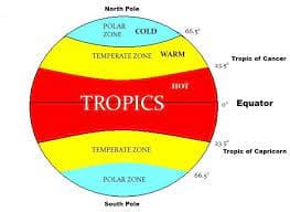
- The fact that the earth is spherical in shape results in different parts of the earth getting heated differently.
- Based on the heat received from the sun, Earth is divided into three heat zones. They are
Torrid Zone
- It is a region between the tropic of cancer and the tropic of Capricorn.
- This region receives the direct rays of the sun and gets the maximum heat from the sun.
- This zone known as the torrid or the tropical zone
Temperate zone
- This zone lies between the Tropic of cancer and the Arctic circle in the Northern Hemisphere and between the Tropic of Capricorn and the Antartic circle in the southern Hemisphere.
- This zone gets the slanting rays of the sun and the angle of the sun’s rays goes on decreasing towards the poles.
- Thus this zone experiences moderate temperature.
Frigid Zone
- The frigid zone lies between the Arctic circle and the North Pole and between the Antartic circle and the South Pole.
- This region also known as Polar region.
- Since it receives the extremely low temperature throughout the year, these regions are covered with snow.
Rainfall
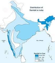
- Rain is a liquid water in the form of droplets that have condensed from atmospheric water vapour and then become heavy enough to fall under gravity.
- Rain is a major component of the water cycle and is responsible for depositing most of the fresh water on the Earth. It is the source of water for all purposes.
- There is a close relationship between the temperature and rainfall distribution.
- Generally rainfall is high in the equatorial region and decreases gradually towards poles. Rainfall is measured by Raingauge.
Air Pressure
- The weight of air above a given area on the earth’s surface is called atmospheric pressure or air pressure.
- The air pressure is measured by Barometer. The standard air pressure at sea level is 25mb.
- At the earth’s surface the pressure is 1.03kg.per sq cm. The variation in standard atmospheric pressure is found both horizontally and vertically.
- Based on the level of pressure, it is categorised into low pressure and high pressure.
- Low pressure area is an area in the atmosphere where the pressure is lower than its surrounding areas.
- In this situation, the wind from the surroundings blow towards the centre of low pressure.
- High pressure is an area of atmosphere where the barometric pressure is higher than its surrounding areas.
- In this case, the wind from the centre of high pressure blows towards the surrounding low pressure areas.
- Low pressure system is marked as “L” on weather map, where as the high pressure system is marked as “H”.
- Low pressure systems are also called as a depression and cyclones. High pressure system is called anti cyclones. Low pressure leads to cloudiness, wind, and precipitation.
- High pressure leads to fair and calm weather. Isobar is used to show the distribution of air pressure.
- Humans are not sensitive to small variation in air pressure.
- But the small variations in pressure that do exist largely determine the wind and storm patterns of the earth.
- The distribution of atmospheric pressure is controlled by altitude, atmospheric temperature, air circulation, earth rotation, water Vapour, atmospheric storms etc.
Measuring air pressure
Meteorologist uses barometer/aneroid barometer to measure the air pressure. Barograms are used for recording continuous variation in atmospheric pressure.
Humidity
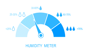
- Humidity refers to the degree of water vapour present in the atmosphere in gaseous form in particular time and place.
- It ranges from 0-5 percentby volume in atmosphere. Climatically it is an important constituent of the atmosphere and its quantity depends on the level of temperature.
- So, the level of humidity decreases towards poles from equator. Humidity is expressed in different ways.
- Specific humidityis a ratio of the water vapor content of the mixture to the total air content on a mass basis. It is expressed in grams of vapour per kilogram of air
- Absolute Humidityis the mass or weight of water vapour present per unit volume of air. It is expressed usually in grams per cubic meter of air.
- Relative humidityis a ratio between the actual amount of water vapour present in the air and the maximum amount of water vapour it can hold at a given temperature. It is expressed as a percentage.
- Generally, warm air holds more water vapour than the cold air. When relative humidity reaches 100%,the air gets saturated.
- In this condition the temperature is said to be at dew-point. Further cooling will condense the water vapour into the clouds and rain.
- Relative humidity affects human health and comfortness. Very high and very low humidity are injurious to health. It also affects the stability of different objects, buildings and electrical applications.
Measurement of Humidity
- Hygrometer is used to measure the humidity. (which comprises wet and dry bulb plate side by side in the Stevenson screen)
Wind
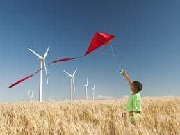
- The horizontal movement of air is called wind. Vertical movement of air is said as air current. The winds move from high pressure to low pressure.
- Unlike other elements a wind is made up of a series of gusts and eddies which can only be felt and not seen.
- Winds get their name from the direction from which they blow i.e, wind blows from south west is called southwest wind.
Measuring wind direction and speed
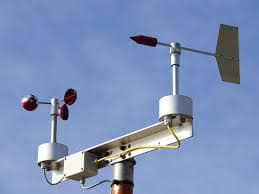
- Meteorologist measures wind direction using wind vane or weather cock. Wind speed is measured by anemometer.
- Wind rose is a diagram used to depict the direction and periods (No. of days) of prevailing winds on map.
- Meteorograph or triple register is an instrument which records wind speed and direction, sunshine and precipitation.
- It also provides graphic representation.
Composition of the Atmosphere
- The atmosphereis essential for the survival of all the organisms on the earth.
- The atmosphere is a blanket of gasesand suspended particles that entirely envelope the earth.
- It extends outward over thousands of kilometres from the earth’s surface.
- Water vapour, aerosolsand tiny solid particles occur in varying quantities as suspended material.
- These are responsible for weather phenomena as they have ability to absorb and release heat energy.
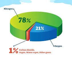
- The atmosphere is composed of mixture of many gases, water vapour and other solid particles.
- The major components are nitrogen(78%), oxygen (21%) and other gases (1%).
- Argon, Carbon dioxide, Neonand the other gases found in the atmosphere
Structure of Atmosphere
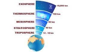
Layers of the Atmosphere
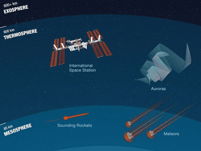
- The atmosphere is divided into five distinct layers based on the temperature variations. They are,
- Troposphere
- Stratosphere
- Mesosphere
- Ionosphere (Thermosphere)
- Exosphere
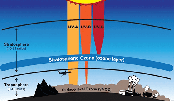
Troposphere
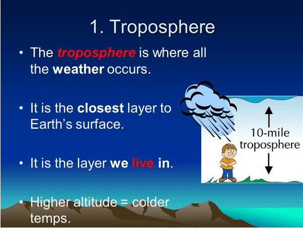
- The troposphere is the lower most layerof the atmosphere.
- It extends approximately to a height of 8 kmfrom the poles and 18 km from the equator.
- The height of the tropospherechanges seasonally also.
- It increases during summer and decreases during winter.
- All weather phenomena occur in this layer as it has dust particlesand water vapour.
- This layer has cloudswhich produce precipitation on the earth.
- The Sun’s rays directly fall on the earth and then they are reflected back into the atmosphere.
- The temperature decreases in the troposphere with increase in altitude at the rate of 1 degree C for 165 metre or 6.5 degree C for every 1000 metres of ascent.
- This is known as lapse rate of temperature.
- This is the densest layer as it contains 70 to 80 percent of gases.
- The outer boundary of the troposphere is called Tropopause, which is about 1.5 kilometer thick.
Stratosphere
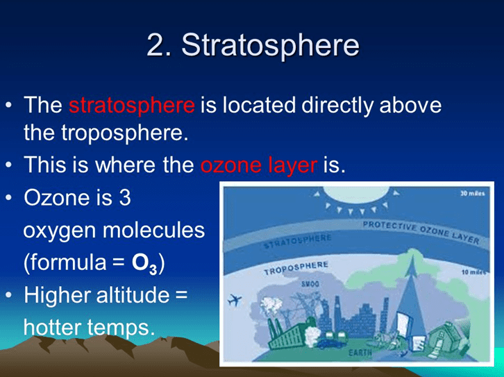
- It is the second layerof the atmosphere found above the troposphere.
- It approximately extends up to a height of 50 kmfrom the earth’s surface.
- Temperature is constant up to a height of 20 km and increases gradually up to the stratopausewhere temperature is nearly -4degree C.
- The lower part of this layer is highly concentrated with ozone gas which is called as ‘ozonosphere’.
- It prevents the ultra-violet rays from the Sun to enter into the lower part of the atmosphere as the rays are highly harmful it causes skin cancer and other ill effects to living organisms.
- But the ozone layersafeguards the life on the earth.
Mesosphere
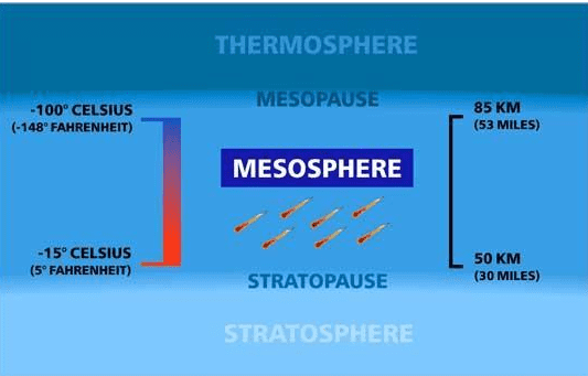
- The mesosphere is the third layerof the atmosphere found approximately up to a height of 85 km above the surface of the earth.
- It is the coldest layer of the atmosphere. The temperature decreases with increase of altitude due to the absence of ozone.
- Its upper boundary is called mesopausewhere temperature reaches 290 8C.
- Luminous noctilucent cloudsform here due to the presence of cosmic dust.
- Meteors falling from the space get burned in this layer.
- It is because when meteorshit the air, the air gets compressed and heated up causing meteors to burn out.
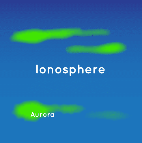
Ionosphere (Thermosphere)
- The ionosphere is the fourth layerof the atmosphere extending approximately up to a height of 400 km.
- The temperature increases rapidly up to 1,000 8C.
- It is due to the absorption of very short wave and high energy solar radiation by the atoms of hydrogenand oxygen
Thermosphere
- When light energyis transformed into heat energy, some gas molecules lose or gain electrons and become the charged particles called ions.
- The charged particles forming the lower part of the thermosphere as a zone, is called Ionosphere. These ionised particles create auroras at higher latitudes.
- Ionosphere can reflect radio wavesback to the earth.
- This facilitates long distance wirelesssatellite communication.
- The credit of discovering ionosphere goes to Hennellyand Heaviside.
Exosphere
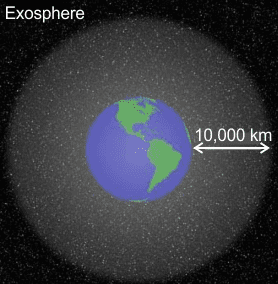
- The upper most layerof the atmosphere which extends into the outer space from above 400 km up to 1600km.
- It has rarefied contents. It contains mainly oxygenand hydrogen atoms.
- These atoms can travel hundreds of kilometres without colliding with one another.
- Thus, the exospherehas no longer behaves like a gas.
- The temperature increases with increase of altitudeand it ranges as high as 1650 degree C.
- The gravitational pull is minimal in this layer.
- This layer gradually merges with the space.
Ozone and Ozone Depletion
- Ozone (O3)is form of oxygen that combines three atoms into each molecule.
- It absorbs and filters the harmful ultraviolet B radiationcoming from the sun.
- This way the ozone layerprotects all life on earth. However, ozone is harmful when it develops near the ground.
- It causes health problemslike asthma and other respiratory illness.
Ozone Depletion
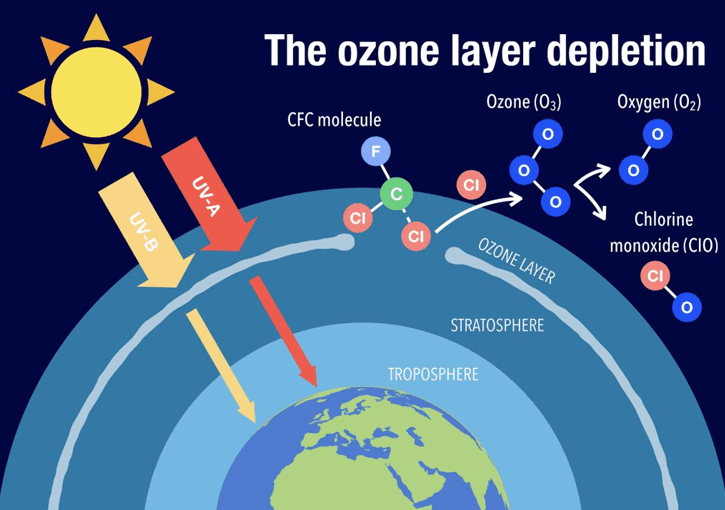
- A steady decline in the concentration of ozone in the earth’s stratosphere (the ozone layer) is called ozone depletion.
- Ozone depletionoccurs when chlorofluoro carbon (CFC) and halon gases, formerly found in aerosol spray cans and refrigerants are released into the atmosphere and they cause chemical reactions that break down ozone molecules and reduce the concentration of them.
- Nitrogen oxidereleased by emitted by supersonic aircrafts can also destroy the ozone molecules to break down.
- Ozone-depleting substancesare present throughout the stratospheric ozone layer because they are transported great distances by atmospheric air motions.
- The severe depletionof the Antarctic ozone layer known as the “ozone hole” occurs because of the special atmospheric and chemical conditions that exist there and nowhere else on the globe.
1. UV causes a chlorine atom to break way from the CFC molecule.
- The free chorine atom hits an ozone molecule.
- The chlorine atom plus one oxygen atom away.
- A free oxygen atom hits the chlorine monoxide molecule.
- The result is another free chlorine atom.
- Free chlorine will continue to deplete ozone in the stratosphere.]
- The very low winter temperatures in the Antarctic stratosphere cause polar stratospheric clouds (PSCs) to form.
- Special reactions that occur on PSCs, combined with the relative isolation of polar stratospheric air, allow chlorineand bromine reactions to produce the ozone hole in Antarctic springtime.
- Satellite imagesof the earth over last decades observed that the atmospheric ozone layer is getting thinner.
- On October 2, 2015, the ozone hole was recorded to its maximum size of 28.2 million sq.km over Antarctica.
- The size of the ozone hole is largerthan the size of continent of North America.
- The ozone holes over Antarctica allow the ultraviolet radiationto enter and cause global warming, skin cancer, eye cataract and even blindness.
- Depletion of the ozone layer has consequences on human, animal, plants and micro organisms.
- This typically results from higher UVlevels reaching us on earth.
- Research confirms that high levels of UV rays cause non-melanoma skin cancer.
- To protect the ozone layer for our future generation, avoid using products which are emitting pollutants such as aerosol sprays, blowing agents for foams and packing materials, as solvents and as refrigerants.
SPREAD OF OZONE HOLE[from 1979-1990 and 2000-2008]
Temperature and Heat Budget
- Air temperature of a particular place denotes the degree of hotness or coldness of air at a given place. It is measured in Celsius.
- Let us understand how the earth is heated.
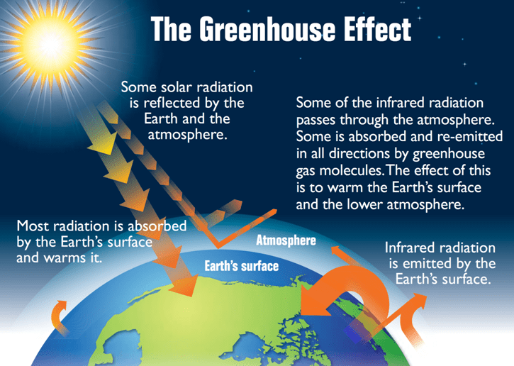
- The surface of the earth is heated by the sun’s rays in the form of short wave radiation.
- The heat received by the earth is called ‘Solar Radiation’or ‘Insolation’. Heating of atmosphere is an indirect process. The processes are:
-
Terrestrial radiation
- The solar radiationreflected by the earth’s surface is called ‘Terrestrial radiation’.
- Terrestrial radiation supplies more heat energy to the atmosphere due to its long wave length.
-
Conduction
- The heat energyfrom the earth’s surface is transferred to the lower atmosphere which is directly in contact with the surface by the process of conduction.
-
Convection and advection
- The movement of air moleculesin vertical and horizontal direction is called as ‘convection and advection’
- This movement carries heat energy to the various parts of the earth and at different altitudes.
Heat budget
- The heat energy reflected, absorbed and radiated back into the space equals the energy received by the earth.
- Incoming radiation and the outgoing radiation pass through the atmosphere.
- The earth maintains its optimum temperature.
- When 100% solar radiationreaches the earth’s atmosphere, 35% is reflected back to space by clouds, water bodies and ice covered areas.
- This heat does not heat either the earth or atmosphere.
- Of the remaining 65% of heat, 14% are absorbed by the atmosphere and 51% are absorbed by the earth’s surface (34% of direct solar radiation and 17% from scattered radiation).
- 51% received by the earth are radiated back to the space directly as terrestrial radiation.
- In total, 17% are radiated to space directly and 48% are absorbed by the atmosphere (14% from insolationand 34% from terrestrial radiation) are radiated back to space gradually.
- Therefore, 65% heat received from the sun is balanced by the 65% radiated by the earth.
- This balance between the incoming and the outgoing heat energy is called the global heat energy balance.
Distribution of Temperature
- Distribution of temperature varies both horizontallyand vertically.
- Let us study it under
- Horizontal Distribution of Temperature
- Vertical Distribution of Temperature
- A) Horizontal Distribution of Temperature
- Distribution of temperature across the latitudesover the surface of the earth is called horizontal distribution of temperature.
- On maps, the horizontal distribution of temperature is commonly shown by isotherms.
- Isotherms are line connecting points that have an equal temperature at mean sea level.
Factors Affecting the Horizontal Distribution of Temperature
- The horizontal distribution of temperature on the earth’s surface varies from place to place.
- Following are the factors affecting the horizontal distribution of temperature of the earth:
-
Latitude:
- The angle formed by the solar radiation to the ground is called ‘angle of incidence’.
- The solar radiationpasses vertically along the equator.
- The angle of incidence decreases from equator towards the poles.
- The area heated by the solar radiation increasestowards the poles and therefore, temperature decreases from the equator to the poles.
-
Distribution of land and water:
- Land is heated and cooled at a faster rate due the conduction processwhereas water is heated and cooled at slower rate due to convection process.
- Water takes 5 times of heat energyto heat a unit area compared to land.
- Thus, the land will have higher temperature than the water in summer and vice versa during the winter.
- So more land mass in northern hemisphere(15.28C) leads to higher average temperature than the southern hemisphere (13.38C).
-
Ocean currents
- Warm ocean currentscarry warm water from the tropical region towards the poles and increase the temperature while cold ocean currents carry cold water from Polar Regions and reduce the temperature along the coasts.
-
Prevailing winds:
- Warm winds like trade wind and westerly, that carry higher heat energy, increase the temperature while cold polar easterlies carry lower heat energy from polar region reduces the temperature.
-
Cloudiness:
- The cloudy skyobstructs the solar radiation from the sun to earth and reduces the temperature.
- But the clear sky during the day allows more solar radiation to reach the earth’ssurface and increases the temperature.
- Meanwhile clear sky at night allows more terrestrial radiationto escape.
- For example, the tropical hot desertsexperience higher temperature at day and lower temperature at night.
-
Nature of the surface:
- The reflectionfrom surface varies based on the nature of land cover.
- The more reflection from the snow surface leads to low temperature accumulation.
- But the dense forest,which reflects less heat energy and absorbs more heat energy, leads to higher temperature.
-
Mountain barriers:
- If a windor air mass blows towards the mountain, it influences the distribution of temperature on either side of the mountain.
- For example, polar easterliesand blizzards are obstructed by Himalayas in Asia and Alps in Europe
- This leads to lower temperature in the northern slopes and higher temperature in the southern slopes of the respective mountains.
Factors Affecting the Vertical Distribution of Temperature
- We all know that the temperature decreases with increasing altitude from the surface of the earth.
- The vertical decrease in temperature of troposphere is called as ‘Normal Lapse Rate’or ‘vertical temperature gradient’ at which the temperature reduces at the rate of 6.5 8C per 1000 meter of ascent.
Vertical Distribution of Temperature
- This is influenced by the following factors:
- Amount of terrestrial radiation reaching the altitude and
- Density of air to absorb the heat energy at higher altitude.
- As both the above said factors decrease with altitude, the temperature also decreases.
Inversion of Temperature
- The condition at which the temperature increases with altitude is called as ‘inversion of temperature’.
- In this condition, warm air lies over cold air.
- The conditions for inversion of temperature are:
-
Long winter nights:
- The bottom layer of the atmosphere in contact with the ground is cooled and the upper layer remains relatively warm.
-
Cloudlesssky
- The higher amount of terrestrial radiation reaches the higher altitude which leads to lower temperature at low level due to clear sky.
-
Dry air near the surface:
- The dry air absorbs less terrestrial radiation and allows them to escape into space.
-
Snow covered ground:
During night, due to terrestrial radiation and higher albedo, most of the heat is lost to the atmosphere and the surface is cooled.
-
Formation of fronts:
- The movement of warm air over the cold air during the formation of the various fronts leads to inversion condition.
-
Mountain wind:
- The subsidence of cold mountain wind at the early morning leads to the displacement of warm air from the valley to higher altitude.
- This type of inversion is called as ‘valley inversion’.
Conversion of Units
Heat Zones of the World
- The earth has been divided into three heat zonesaccording the amount of insolation received.
- These are the Torrid Zone, the Temperate zoneand the Frigid Zone.
Heat Zones
Torrid Zone ( 23 ½ 8N to 23 ½ 8S)
- The zone lying between the Tropic of cancerand Tropic of Capricorn is called ‘Torrid zone’ .
- The sun’s rays are vertical throughout the year and it receives maximum insolation. Thus, this is the hottest zone.
Temperate Zone (23 ½ 8N to 66 ½ 8N and 23 ½ 8S to 66 ½ 8S).
- The temperate zone lies between the Tropic of Cancerand Arctic Circle in the northern hemisphere and the Tropic of Capricorn and Antarctic circle in the southern hemisphere.
- This region never experiences over head sun light but experiences longer days and shorter nights during summer and vice versa during winter.
- This region experiences moderate temperature and is therefore called as ‘Temperate zone’.
Polar Zone (Frigid Zone – 66 ½ 8N to 908N and 66 ½ 8S to 908S )
- The region between North poleand Arctic Circle in the northern hemisphere and South pole and Antarctic Circle in the southern hemisphere is called ‘Polar Zone’.
- This region always receives more oblique rays of the sun and so the temperature is very low.
- It is the coldest zone. This region experiences 24 hours of day and night during peak summer and winter respectively.
- From the above discussion, it is clear that the energy for the earth is from the sun.
Green House Effect
- As seen in the heat budget, the longer wavelengths are absorbed by greenhousegases in the atmosphere, increases the temperature of atmosphere.
- These greenhouse gasesact like a green house and retains some of the heat energy would otherwise be lost to space.
- The retaining of heat energy by the atmosphere is called the ‘greenhouse effect’.
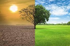
Global Warming
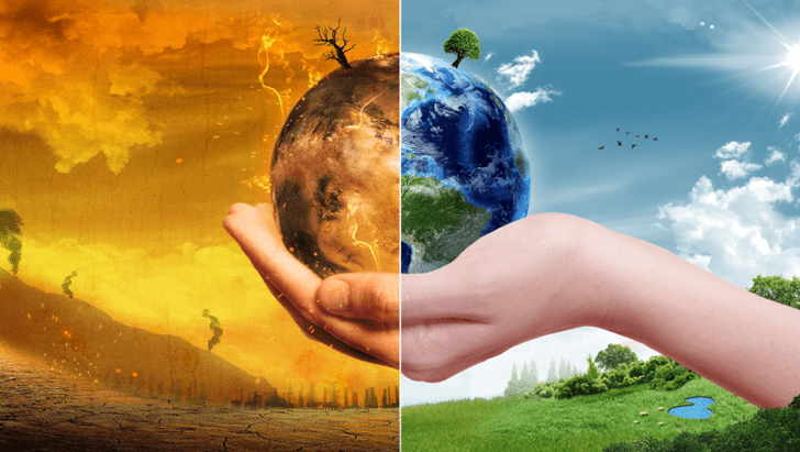
- Global warming is observed in a century scale.
- The temperature increase over the years has been due to the greenhouse gas concentration such as carbon dioxide(CO2), water vapour, methane and ozone.
- Greenhouse gases are those gases that contribute to the greenhouse effect.
- The largest contributing source of greenhouse gas is the burning of fossil fuels leading to the emission of carbon dioxide from industries, automobiles and domestic.
Urban Heat Island (UHI)
- An urban heat islandis an urban area or metropolitan area that is significantly warmer than its surrounding rural area due to high concentration of high rise concrete buildings, metal roads, sparse vegetation cover and less exposure of soil.
- These factors cause urban regions to become warmer than their rural surroundings, forming an“island” of higher temperatures.
Urban Heat Island
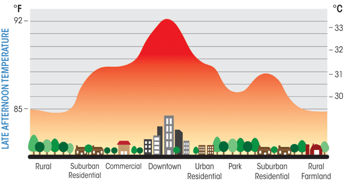
Ways to reduce the impact of urban heat island:
- Increase shade around your home: Planting trees and other vegetation, provides shade and cooling effect through evaporation transpiration and it lowers the surface and air temperature.
- Install greenand cool roofs.
- Use energy-efficient appliancesand equipments.
- Shiftall industries away from the urban area.
- Reduce emissionfrom automobiles.
Atmospheric Pressure and Winds
- Atmospheric pressureis defined as the force per unit area exerted against a surface by the weight of the air molecules above the earth surface.
- The pressure at point ‘X’ increasesas the weight of the air increases.
- The atmospheric pressure is not distributed uniformly over the earth.
- The amount of pressure increases or decreases, according to the amount of molecules, that exerts the force on the surface.
Atmospheric Pressure
- When temperature of the air increases, the air expands and reduces the number of molecules over the unit area. It leads to reduction in pressure.
- Similarly, when the temperature falls, the air contracts and the pressure increase.
- Therefore, the temperature and atmospheric pressure are inversely related.
- Atmospheric pressureis measured by an instrument called ‘Barometer’.
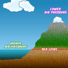
Vertical Distribution of Atmospheric Pressure
- The relationship analysis between altitudeand atmospheric pressure is very peculiar. The upper atmosphere is thin and less dense.
- The pressure at sea level is highest and keeps decreasing rapidly with increasing altitude because of the progressive reduction of the mass above the point where it is measured.
Relationship between Standard Pressure and Altitude.
Horizontal Distribution of the Atmospheric Pressure
- When the air gets heated it expands, becomes lightand rises vertically.
- As air rises, the pressure it exerts on the earth surface is reduced, causing a low pressure area. On the other hand, cool air is denseand heavy.
- As a consequence it sinks vertically.
- It results in additional weight and pressure which cause a high pressure area to occur on the ground.
Horizontal Distribution of Temperature at July
Coriolis Effect
- The rotation of theearth affects the moving objects on the earth surface.
- Free moving objects, affected by the rotation of the earth, do not follow a straight line.
- In the northern hemisphere they drift towards right and towards left in the southern hemisphere.
- A car travelling down a straight road at 95 km/hr in northern hemisphere would drift to the right of the path if the frictionbetween surface and tyre is absent.
- The tendency is called as Coriolis Effectas it was discovered by G. Coriolis.
- This is the reason why racket launching stations are located on the east coastal areas. Example: Sriharihota, French Guyana.
Pressure Belts of the Earth
- The atmospheric pressure belts envelopeon the surface of the earth.
- They are equatorial low pressure belt,sub tropical high pressure belts, sub polar low pressure belts and polar high pressure belts.
Wind Systems
- Wind is the horizontal movement of air molecules from areas of high pressure to areas of low pressure to maintain the atmospheric equilibrium.
- The wind always moves perpendicular to isobars.
- If the earth did not rotate, the winds would blow in a straight path.
- Then the rotation of the earth results in corilois effectand it deflects the direction of the wind.
- Wind direction is identified by an instrument called Wind Vaneand wind speed is measured by Anemometer.
Classification of Wind
Types of Winds
- Winds are classified based on the nature and area of influence as follows; GeneralAtmospheric Circulation, Pressure Belts and Primary Wind System .
- From the equator to the poles, each hemisphere has four pressure beltsand totally there are seven belts on the globe.
Pressure Belts and Primary Winds
- The pressure belts lead to formation of primary wind system as follows:
- The equatorial low pressure belt (between 58oN and 58oS):
- This is the region of calm, weakand changeable winds.
- Due to the high temperature over this region, the air gets heated expands and become lighter and rises upward and creates low pressure over the region.
- This region is a belt of calm and referred to as the ‘Doldrums’.
- The winds blow from the sub tropical high pressure belt towards the equatorial low pressure belt.
- Due to Coriolis Effectthese winds are deflected to the right in the northern hemisphere and to the left in the southern hemisphere.
- As winds are named after the direction from which they originate they are called as the North East and South east trade winds.
- As the winds favoured trading ships they are called as ‘Trade winds’.
- The sub tropical high pressure belt (25o to 35o N and S):
- Air begins to coolwhen it reaches higher altitude over equatorial region and flows towards the poles.
- This wind collideswith the wind coming from the polar region at higher altitude and subsides down over sub tropical latitudes.
- This leads to formation of high pressure belt along the sub tropical region.
- It is said that to avoid the slowing down of ship due to high pressure the horses were thrown into the sea.
- So this belt is called as ‘Horse latitude’.
- The sinking air bifurcated in to two branches towards the equator and poles, they are called as trade winds and westerly respectively.
- Westerliesflow towards the pole from sub tropics and turn towards right and left in northern hemisphere and southern hemisphere respectively.
- The sub polar low pressure belt (50o to 60o N and S):
- The warm westerly windfrom sub tropical region moves towards the pole and collide with the cold polar easterly wind from polar high pressure region and raises up to form sub polar low pressure belt.
- Polar high pressure belt (80o N and S to pole):
- The constant low temperature at the poles due to inclinedsolar radiation and reduced insolation leads to the formation of polar high pressure belt on both poles.
- The high pressure on the surface always coincide with the low pressure at higher altitude while the low pressureon the surface always coincide with higher pressure on the higher altitude.
- High pressure always has divergence of air massesfrom the centre but low pressure has convergence of air.
Basis of Formation of Pressure Belts
- There are two important bases on which the pressure beltsare formed. They are;
- Temperature:
- The equatorial low pressure and polar high pressure belts are formed due to high and low temperature respectively.
- So they are called as ‘Thermally formed pressure belts’.
- Dynamism:
- The sub tropical high and sub polar low pressure belts are formed due to movement and collision of wind system.
- So they are called as ‘Dynamically formed pressure belt system’.
Meridional Cell System
- The cell along with trade winds, equatorial low and sub tropical high pressure belts is called as ‘Hadley Cell’, meanwhile the cell formed by westerly wind along the sub tropical high and sub polar pressure belt is called “Ferrsell’s cell”.
- The cell at polar formed by polar earliest with polar high and sub polar low pressure belt is called ‘Polar cell’.
Meridional Cell
[Polar Front, Polar Cell, mid-lattitudetropopause, tropical tropopause, Ferrel cell, Hadley cell, Cumulonimbus clouds, (mirror image in southern hemisphere) ]
ITZC-Inter Tropical Convergent Zone
- The region where both trade wind systems meet is known as ‘Inter Tropical Convergent Zone’.
Shifting of Pressure Belts and Primary Wind System
- These pressure beltsand primary wind system are dynamic in character as they shift 5 8north and 5 8south from their position along with the apparent movement of the sun.
Secondary Wind System
- Both monsoonsand cyclones are considered as secondary and regional wind system.
- rise vertically, it leads to the formation of steep slope called as ‘Cold Front’.
- Cold Fronts result in the formation of Cumulo nimbus cloudswith heavy rainfall associated with lightning and thunder.
- If warm air is moving over cold air mass, it produces a gentle slope called as’ Warm Front’.